The Magic Glass: Insights into Adventure Navigation

The pace of technological change in the past few decades has been staggering, and the speed at which it continues to advance will define the coming era. One development with huge global impact is interconnection: the instantaneous sharing of data is the shape of today’s society. Whilst adventure, for many of us, is a way to escape the data drag-net, information also shapes the way we get outside. Digital navigation and tracking devices have become part and parcel of adventure, whether that’s riding a bike with an onboard GPS, using a smartphone app to plan a hike or perhaps equipping an expedition with satellite communication. Using such technologies, we’ve simplified the planning phase of many journeys; we’re able to access more remote and challenging terrain, equipped with the knowledge we need to get there and back. But it has not always been that way. This is the story of navigation development from its earliest days to modern satellite communications and positioning systems.
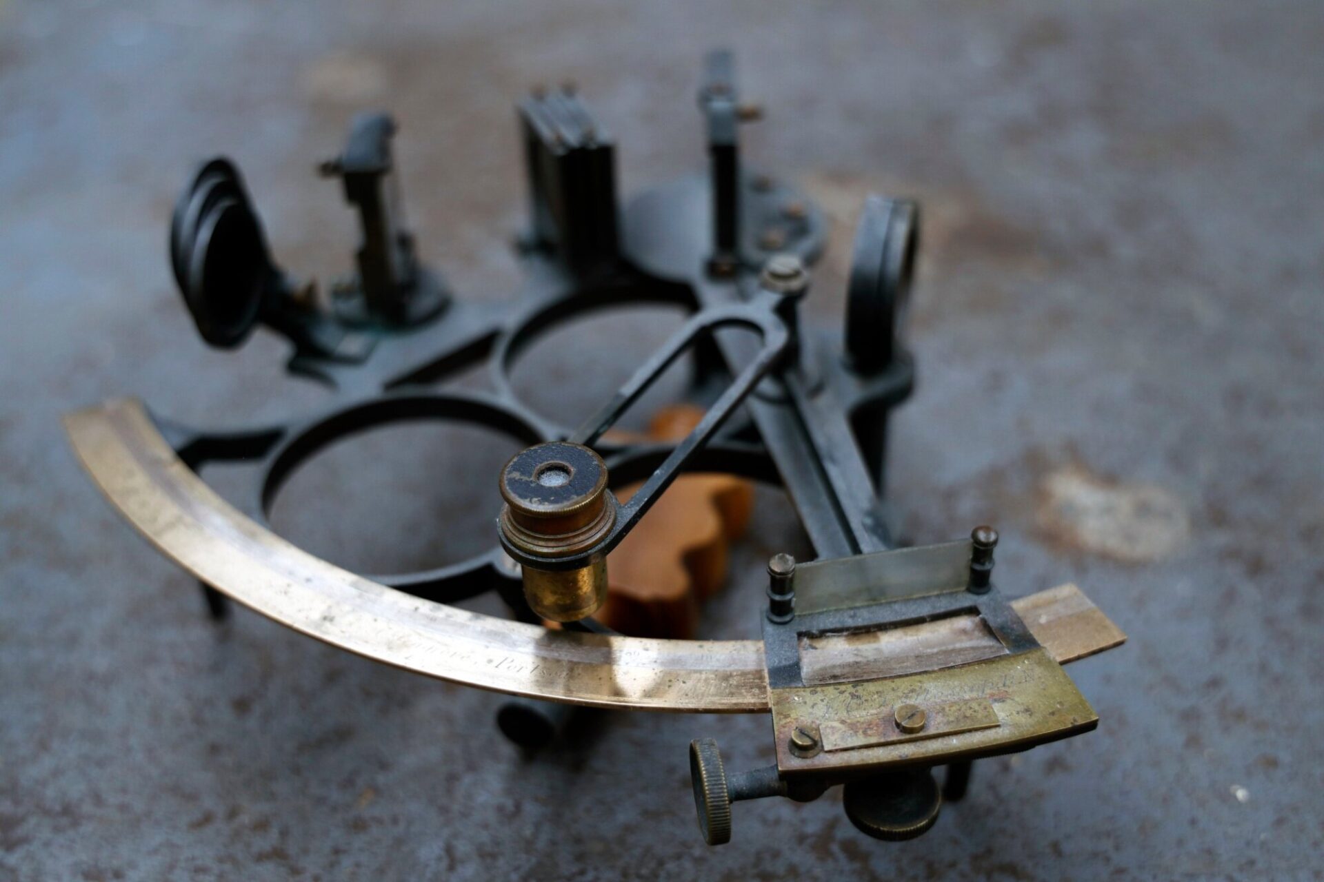
A nineteenth Century sextant at BASE magazine HQ. The sextant, invented in the mid eighteenth Century, was a revolutionary device because it allowed celestial objects to be measured relative to the horizon, rather than relative to the instrument – a difference which creates excellent precision.
A brief history of navigation
The roots of the word navigation lies in ocean travel. In Latin, the word nāvigō, is built upon navis meaning ship and agere, to drive. So when we’re talking about the development of navigational systems, ocean travel is a good place to start.
The earliest forms of open-ocean navigation are considered to have been first practiced by ancient Polynesians. Thousands of years ago, huge voyages were being made between tiny islands over thousands of kilometres of the Pacific Ocean. Using the motion of stars, wildlife, weather and sea conditions, they found safe passage between islands. The knowledge and techniques they developed were passed from master to apprentice and eventually between communities through oral tradition. The voyages of discovery made by ancient Polynesians are among the greatest feats of exploration in human history.
Then came the introduction of navigational instruments. While the Polynesians are thought to have developed their own basic tools, the utilisation of magnets is what really drove navigational tools forwards. While it is recognised that the Ancient Greeks understood magnetism, historians believe Chinese scientists to have been the first to harness magnetic force as a tool for navigation.
During the Han Dynasty, in 2nd Century China, it was discovered that by rubbing an iron a needle against a lodestone (before a form of the mineral magnetite) and a naturally occurring magnet, it was discovered that the needle would temporarily magnetise, thus pointing north. It is understood though that the earliest forms of magnetic compasses were not used for navigation, but instead for fortune-telling and orienting buildings according to the Chinese geomantic system known as feng shui – a system taking into consideration the influence of good and evil within the natural surroundings. (The Chinese also invented gunpowder before the Europeans, but did not use it for military purposes).
By 1040, the Chinese Song Dynasty’s military were using compasses in orienteering and by 1111, the compass was used for maritime navigation. Around the same time in Medieval Europe the use of magnetised needles was also first discovered and it’s been suggested by some scholars that regardless of Eastern technologies, the compass was probably also independently invented in Europe at a similar time.
Open-seas navigation using the the compass kicked off the Age of Discovery in the 15th century, with the Portuguese systematically exploring the Atlantic coast of Africa and by 1492, the Spanish monarchs funded Christopher Columbus’s expedition to sail west to reach the Indies by crossing the Atlantic, which resulted in the discovery of the Americas.
At the end of the 16th Century, navigational tools shifted in focus to measuring the altitude of a celestial body, for example the sun or the moon. The backstaff, or Davis Quadrant, was invented by the English navigator John Davis which was used by observing the sun’s shadow cast by the instrument’s vanes. In 1699 Isaac Newton’s reflecting quadrant made latitude calculations much more accurate, thus replacing the early editions of the backstaff.
The 1750s saw the sextant come to life, invented by astronomer and mathematical instrument maker John Bird. Bird’s innovation was made possible by the developments in horology [clockmaking] inspired by the 1707 Isles of Scilly naval disaster, when almost the entire British naval fleet was wrecked on the Western Rocks with the loss of as many as 2000 sailors. The scale of this tragedy was one factor in the creation of the Longitude Act in 1714, which offered considerable rewards for anyone who could come up with a way of accurately determining longitude at sea. This inspired significant innovation that eventually led to Yorkshire carpenter and maverick inventor John Harrison’s 1761 chronometer named ‘H-4’, one of the world’s first truly accurate clocks. Captain James Cook used a copy of this clock on his second and third voyages of discovery.

The high mountains of the Zanskar Rnage in the Indian Himalaya seen from the air. In terrain like this, having GPS navigation (and the ability to use it) is extremely useful – as is the skill of old-school navigation via map reading and using compass bearings.
Until very recently, the idea of satellites sending messages through space was the stuff of science fiction
Replacing the Davis quadrant and Newton’s Octant, the sextant became the dominant instrument for navigation in the mid eighteenth Century. Derived from the Octant, using mirrors, the angles of reflected light from a celestial body (often the North Star) would be measured to determine distance. The sextant demands a trained eye and learned skill, with small errors leading to huge miscalculations of position. The sextant was a revolutionary device because it allowed celestial objects to be measured relative to the horizon, rather than relative to the instrument – a difference which creates excellent precision.
By the 1890s, radios began to appear on ships at sea. Not long after lighthouses and buoys were placed on headlands and offshore rocks to act as marine signposts to highlight hazards, pointing to safe channels for approaching ships. In 1940 American philanthropist and physicist Alfred Lee Loomis designed the first version of electronic air navigation system which was later developed into LORAN (long range navigation system). This worked by two radio transmitters sending signals from one to the other. By measuring the delay between the signals, the distance between them could be calculated.
The beginnings of the satellite age
In the first half of 20th Century, the concept of using space to send messages around the world was material for science fiction writers. Literally. In 1945, by combining his imagination with German rocket science from World War II, English science fiction writer Sir Arthur C Clarke (who co-wrote the screenplay for the 1968 film 2001: A Space Odyssey) first described a version of what we now know as satellite communication.
His design suggested placing stations (although physically manned by people) into a very specific orbit, at an altitude of 22,236 miles and at a speed of 7,000mph meaning they would orbit at the same rate as Earth’s rotation eating they would effectively be stationary over Earth. This is what would come to be known as geostationary orbit, which allows the same satellites to connect with earth 24 hours a day rather than signals to be interrupted as a satellite moves out of range by flying to the other side of the planet.
Two worlds, two systems: GPS vs GLONASS
In October of 1957, The Soviet Union launched the first ever satellite into orbit. The small polished metal sphere, named Sputnik, was just 58cm in diameter had four external radio antennas to broadcast radio pulses. While Sputnik survived just three weeks in active orbit before running out of battery, its success triggered the Space Race, marking the beginning of a new era of political, military, technological and scientific developments.
In 1973, the U.S. Department of Defence started the GPS (Global Positioning System) project, launching the first prototype spacecraft in 1978. Four years later, satellites of the similar Russian GLONASS system were put into orbit.
Owned by the US government and operated by the US Space Force, each satellite as part of the the Global Positioning System circles the Earth twice a day at an altitude of approximately 20,200 km, providing geolocation and time information to a GPS receiver anywhere on Earth where there is an unobstructed line of sight to four or more GPS satellites. Originally limited to use by the US military, civilian use was allowed from the 1980s following an executive order from President Ronald Reagan.
By 2010, GLONASS had achieved full coverage of Russia’s territory and in October 2011 the full orbital constellation of 24 satellites enabled full global coverage.
Over the decades that followed, Global Positioning System went through a number of significant upgrades all adding to the accuracy and the strength of the signals. During the 1990s though, GPS quality was degraded by the United States government in a program they called Selective Availability. In May 2000 when Selective Availability was lifted by a law signed by President Bill Clinton, GPS had about a five-metre accuracy. GPS receivers released in 2018 that have much higher accuracy, pinpointing to within 30 centimetres.
For navigational devices, being able to use both the GPS and GLONASS constellations means they have far more satellites available which makes fixing locations far quicker and more accurate, particularly in areas where physical obstacles like tall buildings, tree cover or mountain ridge lines might cause a weak signal.
Receivers
Today, the range of different GPS units available leads the charge when it comes to navigational tools, from smartwatches, satellite tracking and messenger devices to mapping apps on a mobile phone. But how do they actually work?
Using a process called trilateration, these devices send signals to connect with satellites to triangulate the user’s location. For example, if the signal being received is 10 miles from the satellite, you could be anywhere within a 10 mile radius. If you know your are then 15 miles from a second satellite, you now have a second radius which must converge with the first. By adding a third radius sphere, from which you are 15 miles from also, your location can now be pin-pointed within the small area where those areas overlap.
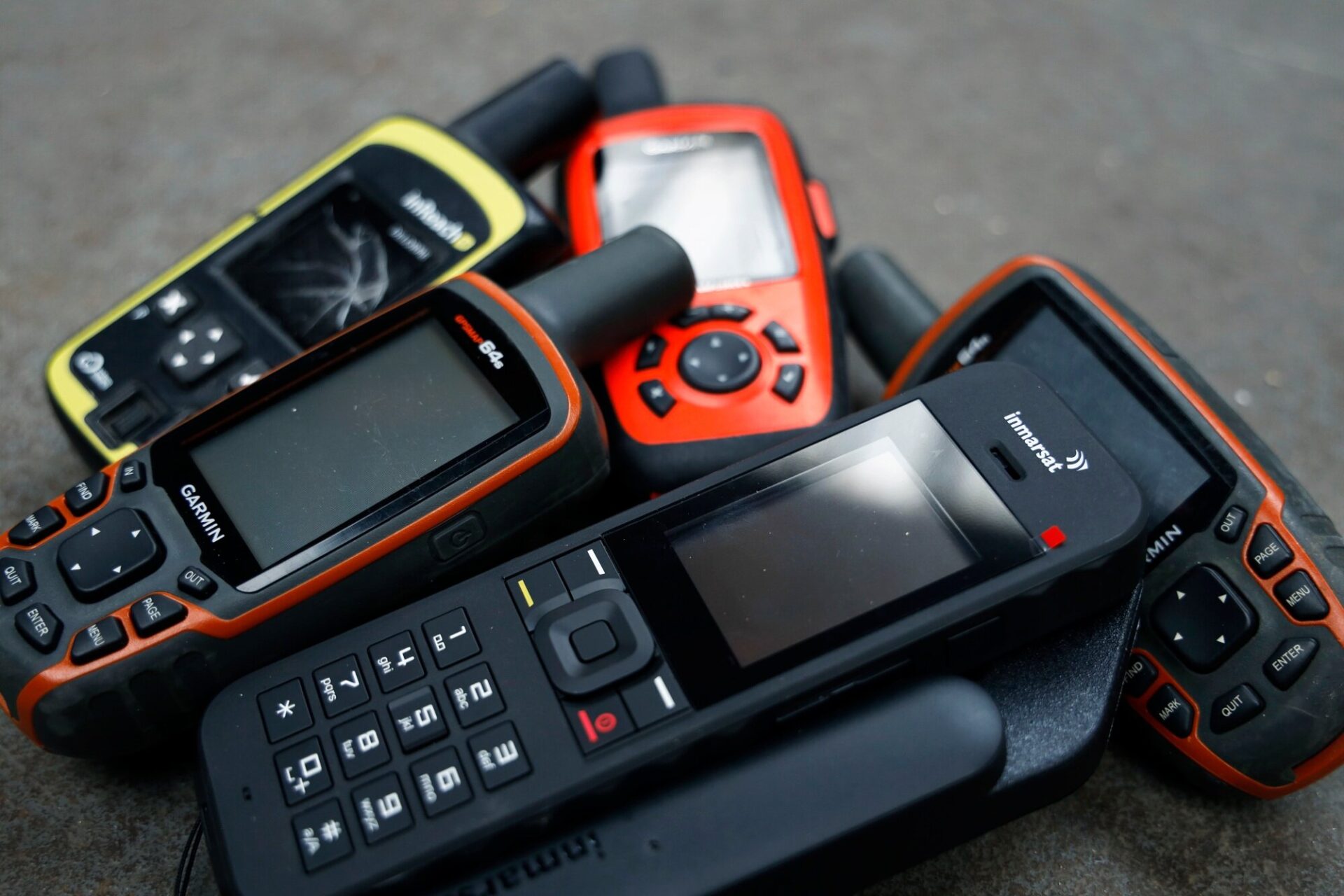
Modern GPS units including the Garmin InReach and a modern Inmarsat satellite phone.
Each satellite carries an atomic clock from which the GPS device can compare both the time the signal was sent by the satellite with the time the device receives the signal and thus calculate how far away the satellite is. In order to calculate the longitude and latitude of the device, it must connect with the signals of at least three satellites. To also calculate altitude known as a 3D location, the GPS must lock onto the signal of a fourth satellite.
Once the device’s location is determined, the speed it’s travelling at can be calculated simply by continually updating position with the satellites and measuring the distance the user has traveled in a specific time. If information such as destination is inputted, the receiving device can then simply calculate distance and time to destination based on the user’s current speed of travel.
Going one step further, satellite communication devices like the Garmin InReach allow two way communication via text or email. This connects friends and family or behind the scenes support to the user on the ground or the chance to trigger an SOS message to a centralised global monitoring and response centre.
Real-world application
Tom Bodkin, founding director of Secret Compass, has been coordinating commercial expedition support for the best part of the last decade, whether that’s leading adventure tourism in the Iraqi Kurdistan, or for TV projects deep in the Congo. For Tom, GPS tracking and communication devices like this are absolutely vital.
“Above all, the real advantage of these things now is the two way messaging capability,” explains Tom. “On some of the older models you could ping for SOS but you couldn’t add any context. It was just ‘I’m in the shit, help.’ But what does that really mean? The likelihood is that it’s way more complex than that. The rescue effort probably needs to be tailored for whatever is going on and you’ll probably need to move to a safe location. Because of that, not having the messaging system means the whole rescue is massively delayed and ultimately that can be the difference between life and death. In my experience, the ability to communicate two ways solves that.”
From anywhere in the world, equipped with pocket sized GPS communication devices such as the Garmin InReach means that from the Secret Compass offices in the UK, Tom’s team can communicate with expeditions in real time.
“For high risk TV shoots that’s essential,” says Tom. ‘When we’ve got journalists out in Iraq or Syria for example, we need to know exactly where they are and how it’s going for to keep on top of dynamic security risks. But at the same time we might have a team running a pretty dangerous river somewhere pretty remote. The trackers in this instance are super useful just to be able to quietly keep an eye on the team’s progress.”
For expedition teams like this, where making connecting with satellites is absolutely vital regardless of how remote their position, satellite communication devices like the Garmin InReach opt for another satellite constellation all together. The Iridium network orbits just 780 km above the Earth with 66 satellites spaced out to offer pole-to-pole coverage. With stronger signals, shorter connection time and lower latency, the satellites are in motion at a speed of 27,350 km/h.
“In Mongolia a few years ago we had a team trying to coordinate an evacuation with us in the UK,” explains Tom. “The problem is they were in an east to west valley in the mountains, and the sat phone didn’t have a clear shot north or south to connect with a satellites. Now, with the InReach devices using the Iridium network, that’s not an issue.” With innovative updates like pairing the device to a smartphone, the user’s experience is made far simpler, meaning there’s more communication which ultimately might prevent a rescue or evacuation from needing to take place.
“The ability to type a message via an iPhone rather than the actual GPS device might not seem like such a big deal,” says Tom. “But for us when we’ve got TV crew teams or adventurers out in the mountains, they’ve got a million other things to be thinking about but we really need those daily updates. The more usable it is, the more likely it is that we get those daily check-ins.”
The future
Today, we’re witnessing a kind of modern day Space Race, one in which billionaire entrepreneurs have occupied the position of governments in the past. Elon Musk’s Starlink satellite constellation for example will see as many as 12,000 small satellites orbit at just 550km with the aim to provide global internet coverage. In 2019, Amazon jumped into the race with plans for their own broadband satellite constellation called Project Kuiper while Virgin Group and Japan’s Softbank have also invested heavily in similar projects.
At the same time we’re seeing further development from governments across the world investing in more satellite systems. China’s BeiDou Navigation Satellite System for example began global services in 2018 and Japan’s Quasi-Zenith Satellite System (QZSS), with satellite navigation independent of GPS is scheduled for 2023. There are also the European Union Galileo positioning system, and India’s NavIC.
In 2018 it was estimated that some 5,000 satellites were in orbit with about 1,900 of those operational. With constellations from single projects looking to launch tens of thousands of satellites into space, the future is certainly looking bright for interconnectivity with issues of weak signal or patchy coverage likely to soon be a problem of the past. As for the night sky though, as orbiting satellites are clearly visible the future might be equally bright.
Don’t miss a single adventure
Sign up to our free newsletter and get a weekly BASE hit to your inbox
Other posts by this author


Review • Chris Hunt • Jun 27, 2023
Review: Montane Fireball Lite Hooded Jacket
Versatile mid-layer designed for active fast and light adventure

Review • Chris Hunt • Jun 23, 2023
Review: Pas Normal Studios Essential Shield Waterproof Jacket
Premium waterproof cycling jacket
You might also like

Review • Matthew Pink • Jun 06, 2026
3 summer camping essentials for adventures in 2026
We've found 3 underrated gems to up your camping game this summer.

Review • Matthew Pink • Jun 06, 2026
Men’s Mountain Shell Guide Summer 2026
Three options to keep the pesky wind at bay when cracking on this summer.

Review • Matthew Pink • May 18, 2026
Review: Danner MTN45 Low Shoe
A lighter, more agile, low-cut format from the US brand Danner.