A Practical Guide to Navigating By The Stars
Millennia ago, in the South Pacific, ancient seafarers ventured out into the vast ocean on canoes made with stone-age tools, using only natural clues, such as the stars, to guide them. Starting in Taiwan around 2,000BC, over a period of three thousand years, these intrepid explorers tirelessly pushed into the Trade Winds, discovering Hawaii in the north, New Zealand in the south, Easter Island in the east and everything in between. If that wasn’t miraculous enough, they then accurately charted this huge body of water, an area larger than the continental United States, without instruments or charts.
But what relevance do these ancient techniques hold today for the modern adventurer? In May 2022, I travelled to Tahiti on a mission to rediscover the lost art of navigating naturally. I wanted to know how these expert wayfinders achieved such phenomenal feats of navigation. And to learn if and how we apply those same skills today. I teamed up with the Royal Cruising Club Pilotage Foundation and set a mission to research how natural navigation can aid modern adventurers with high-tech kit. From watching birds to gazing at stars, riding waves and spotting clouds, we hoped to create a new way of navigating that brings together the best of both worlds, embracing technology while celebrating the timeless beauty of natural techniques. In this article I will share some of the techniques I discovered, focusing on stars, that you can use tonight to find your way by land and sea, anywhere in the world.
Pole Stars
Polaris is the most useful star in the sky, guiding us true north more accurately than a compass (which points to the magnetic pole). But for its wonderful accuracy, the North Star has one great flaw; its brightness, or lack of. There are more than fifty brighter stars in the night sky, which means it doesn’t stand out at all when you look north. The trick to finding Polaris is to firstly locate the easily recognisable Plough, which famously looks like a saucepan.
Depending on the time, it could be either way round or even upside down, but regardless of its position the two outer stars – Dubhe and Merak – will always point towards the North Star (see Diagram 1). Simply extend an imaginary line five times the distance between the pointers and Polaris will be the only star in that area of the sky. True north is directly below the pinprick of light. As a compensation for the North Star’s dimness, it more than makes up for it by dutifully staying in one place (unlike every other star that revolves around the sky). The great advantage of this is that once you’ve found Polaris you don’t need to worry about losing it, because it’s not going anywhere.
However, as you travel south, Polaris will drop one degree in the sky for every degree of latitude (60 nautical miles / 111 kilometres). At the North Pole it will be directly overhead, but if you were to continue all the way down to the equator, the North Star will be just a speck on the horizon and when you head into the Southern Hemisphere, it completely disappears from the sky. However, there is a technique the Polynesians developed to make use of Polaris in low southern latitudes, places like Tahiti; they would use the pointers in the Plough (which is visible part of the night) to gauge where Polaris is lying beneath the horizon.
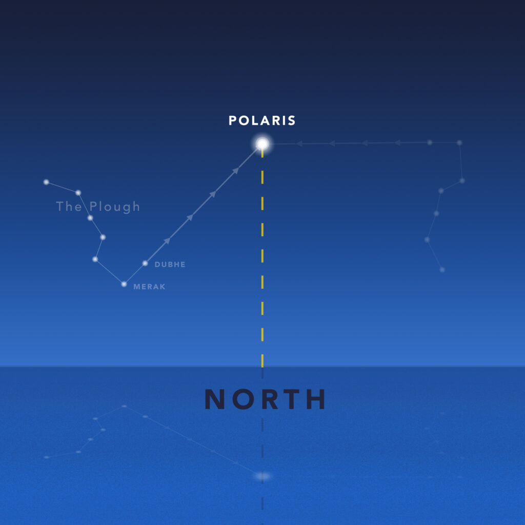
Diagram 1: How to locate Polaris by firstly finding the Plough. Regardless of its position, the two outer stars – Dubhe and Merak – will always point towards the North Star.
The point on the sea directly above this is north. While this lacks the precision of actually seeing the star, it does give you an approximate guide. For more accuracy, you want to turn around and find the Southern Cross. This is slightly more complicated because like the Plough, it’s perpetually spinning around the sky; unlike the Northern Hemisphere, there’s no single star in the Southern Hemisphere that sits directly above the South Pole.
Polaris is the most useful star in the sky, guiding us true north more accurately than a compass
To navigate using the Southern Cross you need to do another ‘line visualisation’ like with the Plough. But firstly you need to actually find the Cross. This is done most easily by scanning the horizon at twilight and finding the two pointers (see Diagram 2), which are some of the first stars to appear after sunset. Soon after, you should see the Southern Cross appear nearby in the darkening sky. Now, for best results, you want to do a double line-up. Firstly, extend a line out from Gacrux towards Acrux and beyond. Secondly, imagine a line between the pointers and then extend another from the middle, going out at right angles. Now visualise this line bisecting the one from the Cross; the point beneath this is due south. As you can imagine, this technique is more complicated than using Polaris to find north, but with practice it does become second nature. On my first attempt I couldn’t even find the Southern Cross (the SkyView app helped me out), but after a few nights I was confidently using it to find my way south.
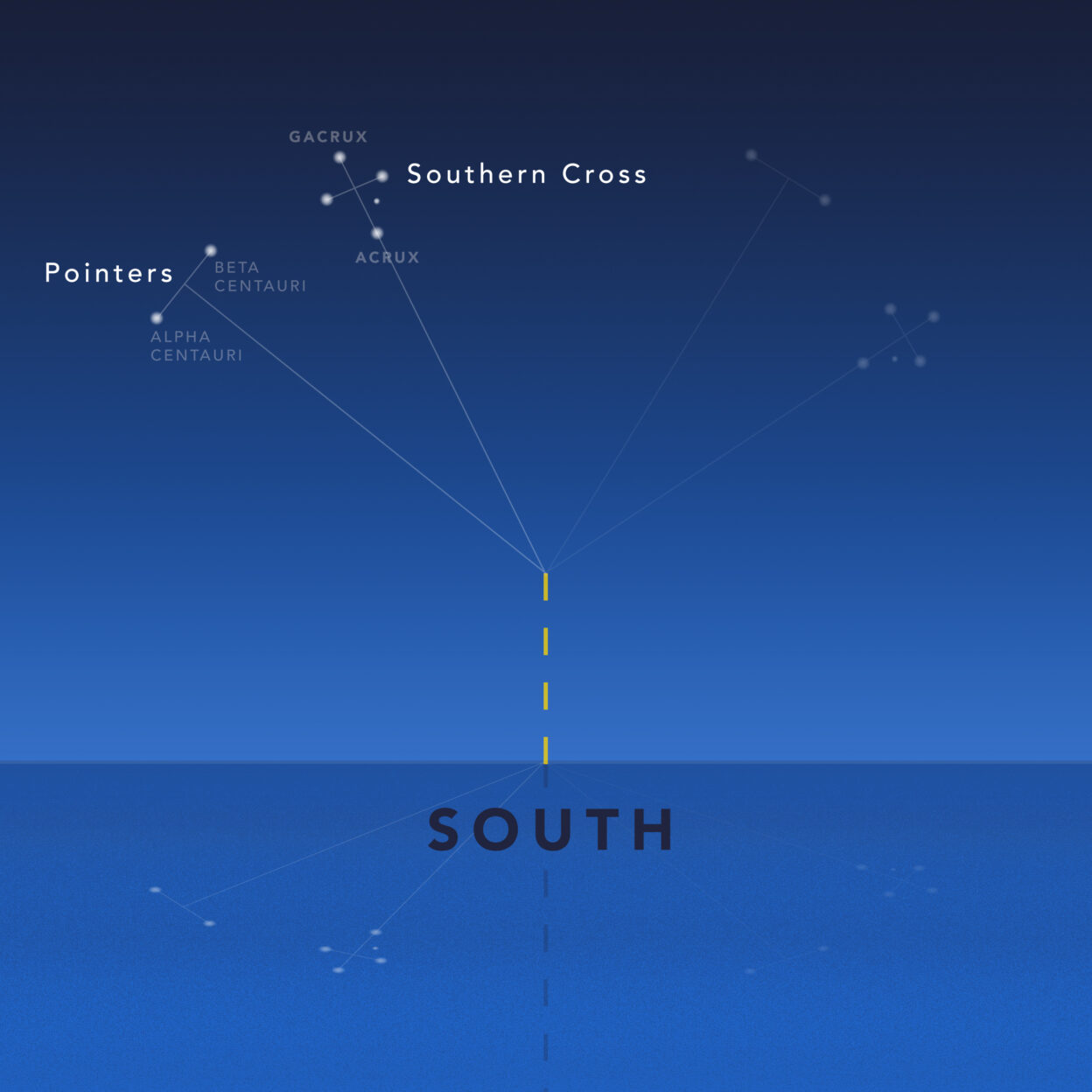
Diagram 2: How to find the Southern Cross.
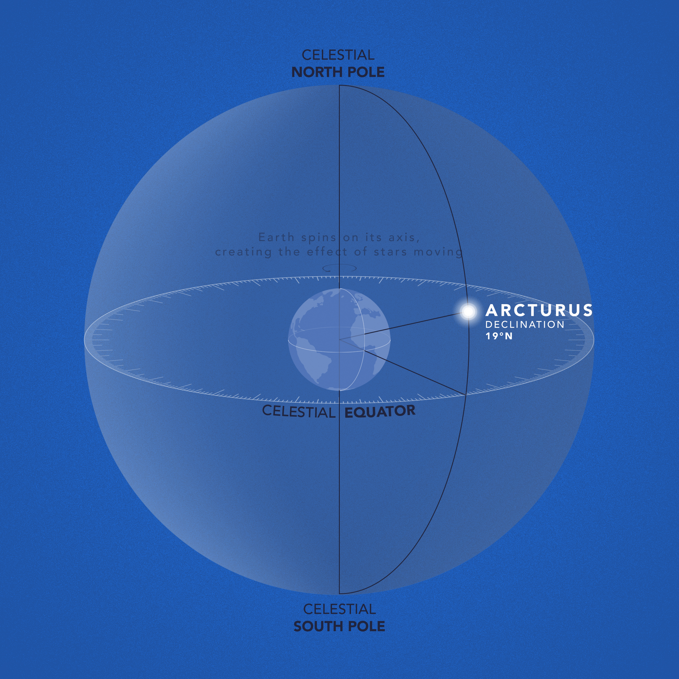
Diagram 3: The celestial sphere.
Horizon Stars
The Polynesians knew that from your location a particular star will always rise at a specific point on the horizon, move through the sky in a predetermined path and then set in the same place. To understand why this happens, it helps to understand a little background theory.
Firstly, we imagine all stars embedded into the ‘celestial sphere’ (see Diagram 3), which is like an orb that surrounds the Earth with its poles and equator in alignment with ours. Every star has a fixed position on the celestial sphere and its ‘celestial latitude’ (position north or south of the celestial equator) is called declination. This is what determines where a star rises; from the equator its horizon bearing north or south of east is equal to its declination. For example, Alnilam, the middle star in Orion’s Belt (see Diagram 4) has a declination of 1° north, so it rises almost due east (89°) and then sets in a mirror-image, almost due west (271°). Sirius, which is the brightest star in the sky found by following a line from Orion’s Belt, has a declination of 17° south, so it rises 17° south of east (107°) and sets 17° south of west (253°), when viewed from the equator.
The bearings change with your latitude, but from the Northern Hemisphere Sirius will always rise approximately E-S-E and set W-S-W. By understanding this theory, all you need to know is a star’s declination and you can predict where it will rise and set; to find this information, you can download a DIY Star Calculator from Tide School.
Quite simply, all navigators needed to do was memorise their favourite tunes and they had a chart of the Pacific
The Polynesians by heart the positions that dozens of stars rose and set, giving them a compass laid out in the sky every night, with shimmering lights guiding them to all the cardinal points, filling in the gaps between the pole stars. If that isn’t amazing enough, this knowledge created the foundations of an even more incredible achievement; they used star bearings to chart the entire Polynesian Triangle, mapping everything within the area between Hawaii, New Zealand and Easter Island. This was done by undertaking a multitude of voyages between islands over multiple generations, perfecting the star bearing of each island in relation to the others around it. Combined with an understanding of average sailing times, the Polynesians had a mental map of the whole South Pacific, a vast maze of volcanic islands, reefs and atolls. To simplify learning, the information was converted into songs, poems and chants. Quite simply, all navigators needed to do was memorise their favourite tunes and they had a chart of the Pacific.
Naturally, you can only use the horizon star technique on stars that rise and set. Not all celestial bodies do; some stars are perpetually circling through the sky, neither rising nor setting. These are called ‘circumpolar stars’ and they can be found in both hemispheres. In the Northern Hemisphere, they all spiral anticlockwise around Polaris, like the Plough. In the Southern Hemisphere, they all spiral clockwise above the south pole, like the Southern Cross. Whether or not a star is circumpolar from your position depends on its declination and your latitude. Firstly, the star needs to be in the same hemisphere in the celestial sphere as your hemisphere on earth. Secondly, your latitude added to the star’s declination must exceed 90. For example, from my boat Luna in Catalonia, where the latitude is 42° north, any star with a declination higher than 48° north will be circumpolar. This means these stars will neither rise nor set, but perpetually circle Polaris, an effect not made by the stars actually moving but by the earth spinning on its axis, giving the appearance of movement in the heavens.
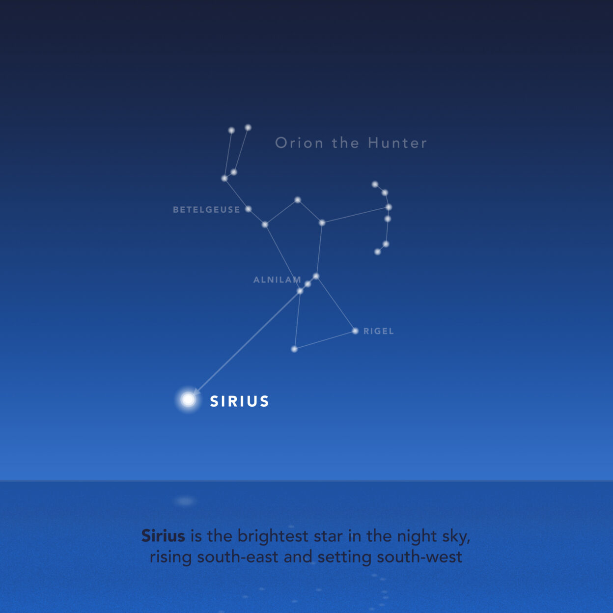
Diagram 4: Using Orion’s Belt to find Sirius, the sky’s brightest star.
5 Keys To Navigating by the Stars
01 POLARIS
Polaris can be seen from everywhere in the Northern Hemisphere and it leads you due north more accurately than any compass. Its altitude in the sky is equal to your latitude!
02 SOUTHERN CROSS
The simplest way to find the Southern Cross is to go out at twilight and look out for the ‘pointers’. These are some of the first stars to appear in the night sky.
03 SIRIUS
Sirius is the brightest star in the sky, found by extending out an imaginary line from Orion’s Belt. From the Northern Hemisphere it always rises south-east, is due south when highest, then sets south-west.
04 DECLINATION
Declination is the celestial equivalent of latitude. If a star’s declination is the same as your latitude, it will pass directly overhead.
05 HORIZON STARS
From your position a star will always follow the same path through the sky, rising at exactly the same point every day and then setting in a mirror-image bearing to the west.
Zenith Stars
Regardless of whether a star is circumpolar or not, apart from Polaris they all share the same pattern of spending half the time rising and then half the time falling. The moment they are highest is called ‘culmination’ and this is of great use to navigators. Firstly, this is because stars always culminate on a due north-south axis. Whether it culminates to the north or south of your location depends on the star’s declination and your latitude. If its declination is more northerly than your latitude, it will culminate due north. But if its declination is more southerly than your latitude, it will culminate due south. At the equator, Sirius will always culminate south because its declination is 17° south. In contrast, Arcturus (see Diagram 5) has a declination of 19° north, so from the equator it will culminate due north, exactly above Polaris. However, from Luna’s mooring in Catalonia (42° north) both stars will culminate due south because their declinations are more southerly than Luna’s latitude.
In addition to guiding you on a north-south axis, culminating stars can help you find your latitude. This is based on the rule that if a star’s declination is the same as your latitude, it will culminate directly overhead. This is called a Zenith Star. Polynesian navigators used the concept to find their way between islands, particularly along the ‘Sea Road’ between Tahiti and Hawaii. Because Arcturus’ declination is the same as Hawaii’s latitude, when they sailed the route from Tahiti, Arcturus would start low on the horizon. But with every 60nm north they travelled, its culmination would rise by one degree (a fingers’ width from your outstretched hand). They knew the precise moment of culmination because Arcturus would be directly above the North Star, once they got north of the equator. Finally, after more than two thousand miles, Arcturus would culminate directly overhead, at their zenith, and they knew they were on the right latitude. All they needed to do then was sail downwind and they’d find home. This was a principle called ‘getting your easting’; to account for the Trade Winds, they always aimed well upwind of their destination so that once they were on the right latitude, they knew whether to turn left or right. On the return journey, they then followed the same technique but using Sirius, which has the same declination as Tahiti’s latitude. If your destination doesn’t have a zenith star, you can still use the technique by learning the altitude different stars culminate from that place and measuring it with your hand, an invaluable skill.
Good luck!
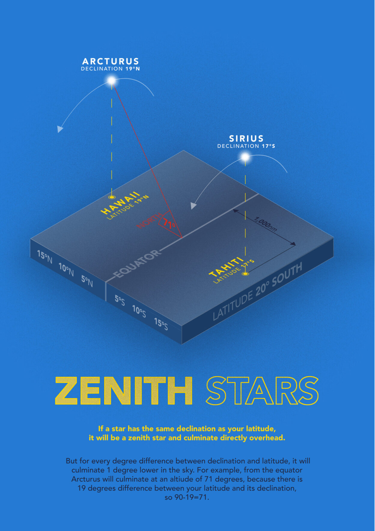
Diagram 5: Zenith Stars.
This story first appeared in issue 09 of BASE magazine. You can subscribe for FREE here to make sure you’re first to get each magazine as soon as it goes to print.
Don’t miss a single adventure
Sign up to our free newsletter and get a weekly BASE hit to your inbox
Other posts by this author
![The wild tide race off Morte Point at the western extremity of North Devon’s Exmoor Coast in a Force 8 easterly gale, with the 4 knot ebb current running at full tilt. In local Devonian lore, Morte Point is ‘the place that God made last and the Devil will take first’, due to the numerous shipwrecks and fishing boat accidents that have occurred on the point. Unusually, there in no ‘inshore passage’ [an area of calmer water immediately offshore] off Morte Point, and the tide race breaks directly on the rocks. Not a place to be in wrong conditions, or without knowing which way the tide is flowing. © David Pickford](https://www.base-mag.com/wp-content/uploads/2021/12/MG_9049-1024x504.jpg)
Story • William Thomson • Aug 27, 2020
An Adventurer’s Guide to Tides and Currents
William Thompson provides a practical guide to understanding the basics of ocean movement